
The above radar image was taken by the doppler radar at Vance AFB (near Enid, OK) just a few moments ago. You can see fairly widespread shower & thunderstorm activity over southern Kansas and northwestern Oklahoma. This activity is occurring ahead of an upper level weather disturbance that is lifting East/Northeast out of Colorado this morning.
This disturbance is just the first in a series that will rotate around a broad area of low pressure currently located over western Nebraska (as seen in the latest watervapor satellite image below) over the next few days.

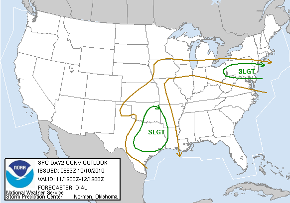
The combination of the disturbances along with a gradual return in low level moisture and instability will result in a risk of severe thunderstorms across portions of the central & southern Plains today and again on Monday. Please note the SPC severe weather risk areas as forecast for today:

and Monday:
Each year it's pretty typical for there to be a "secondary" or mini severe weather season during the transition from summer into fall and winter in the Plains. During this time of year, there is usually no shortage of frontal boundaries and upper air disturbances as cooler Polar air drives Southward. The trick, at least insofar as severe weather development is concerned, can be getting enough low-level moisture and instability into the affected areas to support widespread severe weather.
As you can see by the 10:30 am CDT surface map below, dew points are still only in the 40s to lower 50s in today's severe weather risk area. However, you can see 60s dewpoints not too far to the south in Texas, and this moisture will gradually spread Northward today & tonight.

Just in case you're new to surface map reading (or new to the format above), here is a simple graphic that will help you to decode the information:

No comments:
Post a Comment