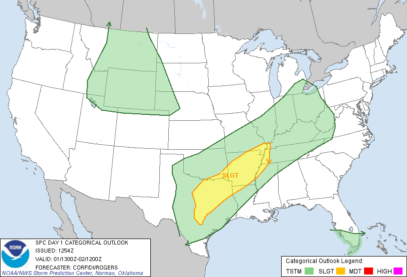
The above image shows the latest Severe Weather Outlook from the SPC, valid for today and tonight. Severe thunderstorms are possible anywhere within the yellow shaded areas on the map. The greatest threat today will be for large hail, some of which could be very large within the areas inside the red and black hatched regions on the image below:

Isolated tornadoes also cannot be ruled out with severe storms today, especially in the areas within the yellow and brown shaded regions on the image below:

A cold front currently stretches across the Midwest into the southern Plains, from northeast Arkansas into northeast Texas, to a surface low near the Big Bend in southwest Texas. A dryline extends Southward from the low across the Rio Grande into Mexico. See the image below for details:

The front and dryline will move little through early afternoon, then the front will make a Southward push and the dryline an Eastward push during the mid and late afternoon hours. By 7pm CDT this evening, the boundaries are expected to be in the positions noted on the image below:

Showers and isolated strong thunderstorms have already developed North of the front across portions of northcentral and northeast Texas, into Arkansas and southern Oklahoma this morning. This activity will persist throughout much of the day. Some of the stronger storms could produce hail to severe limits. Fairly widespread rain will also take place with this activity.
The SPC just issued a Severe Thunderstorm Watch for this region, valid until 3pm CDT:

By mid to late afternoon, scattered thunderstorms are expected to begin forming ahead of the cold front and dryline, from Arkansas, Southwestward into central Texas. As the atmosphere heats & becomes unstable with daytime heating, some of the storms are likely to become severe with large hail likely. Damaging winds and isolated tornadoes also cannot be ruled out.
This activity will bring much needed rain to some parts of central and east Texas. From Arkansas on up into portions of the Tennessee and Ohio Valley region, the rain will be less welcome, as widespread flooding continues in much of this region.
Below is the latest rainfall forecast from the HPC for today and tonight:

As you can see, widespread 5+ inches of rain is forecast from extreme northeast Texas into much of central and southern Arkansas, into the Missouri bootheel. Rainfall is forecast to exceed the amount needed to cause flash flooding within the red hatched areas on the image below:

General rains with a few thunderstorms will increase in coverage across much of central and east Texas overnight tonight and into Monday, behind the cold front. Fairly widespread light to at times moderate rain seems likely for much of the region into the day on Monday. Below is the latest rainfall forecast for Monday from the HPC:

While the forecast amounts for central & east Texas are not heavy, they are certainly welcome, as much of the region (particularly in central and south Texas) has not seen measurable rain in months.
Further Northeast, additional heavy rain will continue to aggravate the flash flooding and river flooding problems that continue in that region.
No comments:
Post a Comment