***Update 10:43 AM CDT:

The severe weather mode in the Austin-San Antonio corridor is shifting away from strong winds and isolated hail, to very heavy rain, which in some cases is causing flash flooding. Sounds odd to be talking about flash flooding in a drought stricken area, however when you dump 2-4 inches of rain in one area over a short period of time, the rain runs out of places to pool and run-off pretty quickly.
If you live in an area that is proned to flooding during this type of situation, plan to stay off the roads until at least 12 Noon. The heaviest rains are ending along I-35 from San Antonio to Austin at this time, shifting to the East (as you can see in the above radar image). Widespread light to moderate rain will continue for at least another hour to hour and a half across the same region.
***Update 10:10 AM CDT:

The strong, gusty outflow winds ahead of the storms have already passed East of the I-35 corridor from Austin into Hays & Comal counties. Now will come the very heavy rains and small pockets of hail. Heaviest rain will take place over a 30 minute period, then taper off to general light to moderate rain for another hour or so...
Gusty winds of 40-50 mph can be expected ahead of the line over Bastrop, Caldwell, Guadalupe, Wilson and Gonzales counties over the next half hour.
***Update 10:00 AM CDT:
Updated radar image. See text on updates below.

***Update 9:50 AM CDT:

Strong to severe thunderstorms with 40-50 mph wind gusts and a few pockets of hail up to 1 inch in diameter can be expected to enter the Austin, Kyle & Buda areas between 10 and 10:30 a.m., and the San Marcos and New Braunfels areas between now and 10:15 a.m.
***Update 9:40 AM CDT:
Flash flooding is going to become a serious problem across central Austin during the next hour. Particularly along and either side of I-35 through the central third of Travis county. A thunderstorm has been sitting nearly stationary there for the past 45 minutes to hour, and this new line of storms is about to move in with additional heavy rains. Radar estimates indicate 2.75 inches of rain has fallen already in this area during the past hour, with an additional 1.5-2.5 inches possible as this line moves through the region over the next hour. Please avoid areas where water covers the road, or where it usually floods in a heavy rain event.
***Update 9:36 AM CDT:
Based on the latest trends, wind gusts of 40-50 mph can be expected across Travis & Hays counties, and wind gusts of 50-60 mph can be expected across Comal, Guadalupe and Bexar counties. The latest radar snapshot is below. Scroll down to the 9:18 a.m. update text for additional details.

***Update 9:26 AM CDT:
Updated radar snapshot. Text of 9:18 am post is still valid...
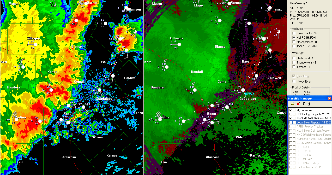
***Update 9:18 AM CDT:

The above snapshot was just taken of the New Braunfels radar. It shows that the strong to severe line of thunderstorms continues to move East/Southeast toward the I-35 corridor. Based on present movement and speed, it will reach the San Antonio area between 9:30 and 9:45 a.m., and the Austin area during the 10 o'clock hour. Points in between can expect the activity to arrive between 9:30 and 10:30.
Very heavy rain, strong, gusty winds and isolated pockets of hail up to 1 inch diameter can be expected with this activity. The green triangles on the left half of the image show where the radar estimates hail is falling. The larger triangle corresponds to 1 inch diameter hail, and the smaller triange corresponds to one-half inch diameter hail.
The right half of the image shows the radar's estimate of wind speed with the storms. Most of the line is indicating 40-50 mph wind gusts ahead of the line, with some pockets of 50-60 mph winds in the brighter green shaded areas.
Brief tornadoes sometimes spin-up along the leading edge of this type of activity. Although that type of scenario cannot be completely ruled out this morning, it is not expected to be a major threat at this time.
-------------------------------------Original Post Below:

The above snapshot was just taken of the New Braunfels radar. It shows that the strong to severe line of thunderstorms continues to move East/Southeast toward the I-35 corridor. Based on present movement and speed, it will reach the San Antonio area by 9:30, and the Austin area during the 10 o'clock hour. Points in between can expect the activity to arrive between 9:30 and 10:30.
Very heavy rain, strong, gusty winds and isolated pockets of hail up to 1 inch diameter can be expected with this activity.

The above image is the same radar in velocity (wind) mode. The circled area shows a band of 55-60 mph wind gusts, as estimated by the radar. This stronger band of winds will track across Blanco and Comal counties during the next 30-45 minutes. Further south, winds of 45-55 mph are indicated along the leading edge of the storms, including those that will impact the San Antonio area shortly...
No comments:
Post a Comment